Uttarakhand Mountains Burning in Wildfires

Uttarakhand Mountains Burning in Wildfires

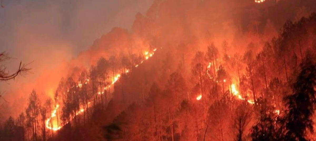
Forest fires have once again ignited in various regions of Uttarakhand, marking two significant incidents in the Gauhari range of the Rajaji Tiger Reserve and along the trek route to the Nilkanth Mahadev temple in Rishikesh.

Find detailed analysis below on reason for wildfire

The fire that erupted in the Gauhari range of the reserve on Thursday evening scorched approximately 1.5 hectares of forest cover, revealed Rajaji Reserve Director Saket Badola on May 31st.

Uttarakhand Wildfires

While the fire in the Gauhari range has been brought under control, efforts to combat the flames persist over an area spanning one hectare in the forest near Pundrasu along the trek route to the Nilkanth Mahadev temple, as stated by Mr. Badola.

Uttarkashi District Disaster Management Officer Devendra Patwal reported additional fires in Barahat, Mukhem, Dunda, and Dharasu ranges, along with the Varunavat hills in the border district of Uttarkashi.

Also Read: California Wildfire Escalates: 11,000 Acres Engulfed, Residents Forced to Evacuate

Emergency response teams including forest guards, Quick Response Teams, NDRF, SDRF, police, and fire brigade personnel are actively engaged in extinguishing the flames across Uttarkashi district.

Following a nearly two-week lull, which saw a significant decrease in forest fire incidents, wildfires resurged on Thursday, affecting 11 areas and consuming more than 13 hectares of forest land across the state, revealed Additional Chief Conservator of Forest, Nishant Verma.

Verma further disclosed that this season has witnessed a total of 1,167 forest fire incidents, resulting in the devastation of nearly 1,600 hectares of land. Tragically, forest fires in Uttarakhand have claimed six lives and left five individuals injured so far, added Mr. Verma.

Why is Uttarakhand’s Forest up in flames? Analysis

The surge in forest fires plaguing Uttarakhand is the result of a complex interplay between natural phenomena and human activities. According to the latest findings from the Forest Survey of India (FSI), Uttarakhand boasts a vast forest cover spanning 24,305 square kilometers, representing about 44.5 percent of its total geographical area.

These forests are primarily populated by highly flammable Chir Pine trees, covering an extensive 3.94 lakh hectares, rendering them susceptible to fires. Moreover, prolonged dry spells across the Himalayas, compounded by factors like excessive biomass, have significantly escalated the risk of wildfires.

A notable contributor to the rampant wildfires is the heightened aridity prevailing in the region, exacerbated by the ongoing heatwave gripping areas such as Nainital and Champawat, which share borders with Nepal. This increased aridity stands as a crucial driver behind the escalating forest fires ravaging Uttarakhand’s landscape.

Furthermore, the absence of substantial rainfall during the winter months has exacerbated the situation. Uttarakhand has experienced deficient winter rainfall and meager snowfall since September, further exacerbating the already precarious conditions, and contributing to the heightened risk of wildfires.

Human Contribution to Uttarakhand Wildfires

A report from the Forest Research Institute, published in 2019 by the Environment Ministry, sheds light on the significant human contribution to forest fires in Uttarakhand. The report indicates that a staggering 95 percent of these fires are a result of human activities.

In the hilly regions, villagers have traditionally practiced burning forest floors to facilitate the growth of new grass and to clear land for agricultural purposes. While this practice may have historical roots, its consequences contribute to the alarming frequency of wildfires.

Moreover, careless actions such as discarding lit bidis or igniting bonfires near forested areas exacerbate the issue, further fueling the spread of wildfires.

Recent incidents have highlighted the extent of human involvement in exacerbating these fires. Authorities have reported numerous individuals in Uttarakhand who have been apprehended for deliberately starting fires. Motivations behind these actions vary, from traditional land-clearing practices to more modern inclinations, such as creating content for social media or simply engaging in mischief.

These findings underscore the urgent need for increased awareness and stricter enforcement of regulations to mitigate the human factors contributing to Uttarakhand’s devastating wildfires.

Frequency of these Forest Fires in India?

India typically witnesses its forest fire season from November to June. According to data from the Forest Survey of India (FSI) website, approximately 36 percent of the country’s forests are vulnerable to fires. Various factors including temperature, precipitation, vegetation types, and moisture levels influence the occurrence of these fires. Environmental experts highlight that factors such as fuel load, oxygen levels, and temperature fluctuations significantly contribute to the ignition of these fires.

Most incidents of fires in the country are reported during the months of March, April, and May. This surge is attributed to the abundance of dry biomass following the end of winter and preceding the onset of summer, as reported by the Indian Express.
Is it Possible to Reduce Wildfires?

Forest authorities propose that reducing fuel sources such as Chir Pine needles, known for their high flammability, can help lessen the intensity of forest fires by disrupting the ‘fire triangle,’ which comprises fuel, heat, and oxygen required for ignition.

The Ministry of Environment, Forest and Climate Change (MoEFCC) outlines four strategies for preventing and managing forest fires: erecting watch towers for early detection, deploying fire watchers, involving local communities, and establishing and maintaining fire lines. The National Disaster Management Authority (NDMA) website distinguishes between two types of fire lines: Kachha and Pucca.

Kachha fire lines involve clearing undergrowth and shrubs while preserving trees to reduce the available fuel. Conversely, Pucca fire lines are clear-cut areas that create a barrier between forest compartments or blocks to contain potential fire spread.

The FSI website explains that satellite-based remote sensing technology and GIS tools have been effective in enhancing fire prevention and management efforts. These tools facilitate early warnings for fire-prone areas, real-time fire monitoring, and the assessment of burnt areas.

Leave a Reply

Your email address will not be published. Required fields are marked *